
Fayl:Relief Map of Poland.svg

Size of this PNG preview of this SVG file: 617 × 600 пиксел. Basqa rezolyutsiyalar: 247 × 240 пиксел | 494 × 480 пиксел | 790 × 768 пиксел | 1053 × 1024 пиксел | 2107 × 2048 пиксел | 861 × 837 пиксел.
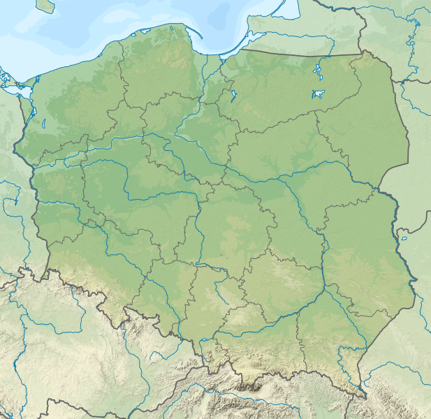
Túp fayl (SVG fayl, 861 × 837 piksel belgilengen, fayldıń ólshemi: 4 MB)
Juwmaq
| Sıpatlama |
Deutsch: Positionskarte von Polen
Quadratische Plattkarte, N-S-Streckung 160 %. Geographische Begrenzung der Karte:
English: Location map of Poland
Equirectangular projection, N/S stretching 160 %. Geographic limits of the map:
|
| Sáne | |
| Fayl deregi |
Óz dóretiwshilik jumısım This vector image includes elements that have been taken or adapted from this file: This vector image includes elements that have been taken or adapted from this file: |
| Avtor |
TUBS |
| Басқа нұсқалары |
|
| SVG genesis | This map was created with Adobe Illustrator by TUBS. |


Licenziyalaw
Мен бұл туындының авторымын, келесі лицензия аясында бұны жариялаймын:
Bul fayl Creative Commons tiykarında licenziyalanǵan org/licenses/by-sa/3.0/deed.en Attribution-Share Alike 3.0 Unported licenziyası.
- Siz bossız:
- Bólisiw – Jumıstı nusqalaw, tarqatıw hám uzatıw
- Remiks qılıw – Jumısqa beyimlesiw
- Tómendegi shártler tiykarında :
- atribut – Siz tiyisli kredit beriwińiz, licenziyaǵa siltemeni usınıwıńız hám ózgertiwler kiritilgenligin kórsetiwińiz kerek. Siz bunı hár qanday aqılǵa say jol menen etiwińiz múmkin, biraq licenziar sizdi yamasa siziń paydalanıwıńızdı maqullawın usınıs etetuǵın tárizde emes.
- birdey shártlerde taratıw – Eger siz materialdı remiks qılsańız, ózgertseńiz yamasa oǵan tiykarlansańiz, óz úleslerińizdi túp nusqadaǵı sıyaqlı birdey yamasa uyqas licenziya tiykarında tarqatıwıńız kerek.

|
I'd greatly appreciate, that you attribute this media file to Wikimedia Commons, if used outside Wikipedia or Commons. For use in publications such as books, newspapers, blogs, websites, please insert here the following line:
|
Fayl tariyxı
Aldın usı fayl qanday kóriniste bolǵanın kóriw ushin kún-ay/waqıt degendi basıń.
| Sáne/Waqıt | Miniatyurası | Ólshemleri | Paydalanıwshı | Pikir | |
|---|---|---|---|---|---|
| házirgi | 23:20, 2021 j. noyabrdiń 30 | | 861 × 837 (4 MB) | Puck04 | fixed SVG code (was "W3C-invalid") + cleanup using text editor; contains raster graphics however |
| 20:54, 2021 j. fevraldıń 3 |  | 861 × 837 (4,18 MB) | SANtosito | Vectorized topo | |
| 21:52, 2011 j. noyabrdiń 30 |  | 861 × 837 (4,87 MB) | TUBS | == {{int:filedesc}} == {{Information |Description={{en|Relief map of Poland}} Equirectangular projection, N/S stretching 160 %. Geographic limits of the map: * N: 55.2° N * S: 48.7° N * W: 13.8° E * E: 24.5° E |Source={{own}}{{Adobe Il |
Fayldıń paydalanılıwı
Tómendegi 2 dana bette bul fayl paydalanılǵan:
Fayldı global paydalanıw
Tómendegi basqa wikilar bul fayldan paydalanadı:
- ab.wikipedia.org joybarında qollanıw
- als.wikipedia.org joybarında qollanıw
- ar.wikipedia.org joybarında qollanıw
- av.wikipedia.org joybarında qollanıw
- azb.wikipedia.org joybarında qollanıw
- az.wikipedia.org joybarında qollanıw
- Şablon:Yer xəritəsi Polşa
- Əyri meşə
- Slovinski Milli Parkı
- Dzivna boğazı
- Yamno gölü
- Baltik dili
- Şablon:Dil (coğrafiya)
- Şablon:Dil (coğrafiya)/doc
- Xel dili
- Blendovka səhrası
- Morskie Oko gölü
- Belka-Snejna mağarası
- Karsibur adası
- Ambarlar adası
- Qrabovski adası
- Haliç dağı
- Jives gölü
- Rozeve burnu
- Lısa-Gora dağı
- Avqustovskaya puşa
- Tuxolskie borı
- Rastoçe
- Rominten meşəsi
- Solina gölü
- Qartal Yuvası təbiət parkı
- Çarne gölü
- Pienini dağları
- ban.wikipedia.org joybarında qollanıw
- Taman Nasional Tatra, Polandia
- Taman Nasional Bieszczady
- Lis taman nasional ring Polandia
- Taman Nasional Wielkopolska
- Taman Nasional Pieniny (Polandia)
- Taman Nasional Gorce
- Taman Nasional Babia Góra
- Taman Nasional Białowieża
- Taman Nasional Biebrza
- Taman Nasional Kampinos
- Taman Nasional Narew
- Taman Nasional Wigry
- Taman Nasional Magura
- Taman Nasional Roztocze
- Taman Nasional Polesie
Bul fayldıń kóbirek global paydalanıw bólimin kóriń.