
Fayl:Japan natural location map with side map of the Ryukyu Islands.jpg

Kórip shıǵıw kólemi: 664 × 600 пиксел. Basqa rezolyutsiyalar: 266 × 240 пиксел | 531 × 480 пиксел | 850 × 768 пиксел | 1133 × 1024 пиксел | 2497 × 2256 пиксел.
Túp fayl (2497 × 2256 piksel, fayldıń ólshemi: 830 КБ, MIME tipi: image/jpeg)
Juwmaq
| Sıpatlama |
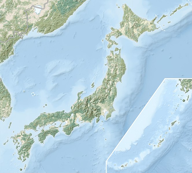
English: Natural Location map of Japan
Equirectangular projection. Geographic limits to locate objects in the main map with the main islands:
Geographic limits to locate objects in the side map with the Ryukyu Islands:
|
||
| Sáne | |||
| Fayl deregi |
|
||
| Avtor | Alexrk2 | ||
| Ruqsat (Bul fayldan qayta paydalanıw) |
Bul fayl Creative Commons tiykarında licenziyalanǵan org/licenses/by-sa/3.0/deed.en Attribution-Share Alike 3.0 Unported licenziyası.
|
||
| Басқа нұсқалары |
|


Fayl tariyxı
Aldın usı fayl qanday kóriniste bolǵanın kóriw ushin kún-ay/waqıt degendi basıń.
| Sáne/Waqıt | Miniatyurası | Ólshemleri | Paydalanıwshı | Pikir | |
|---|---|---|---|---|---|
| házirgi | 21:41, 2022 j. marttıń 9 | | 2497 × 2256 (830 КБ) | Sting | Natural Earth land cover data for Ryukyu Islands |
| 09:44, 2018 j. iyunnıń 22 |  | 2497 × 2256 (794 КБ) | Mardetanha | Reverted to version as of 19:56, 22 March 2011 (UTC) | |
| 19:56, 2011 j. marttıń 22 |  | 2497 × 2256 (794 КБ) | Alexrk2 | RGB | |
| 19:07, 2011 j. marttıń 22 |  | 2497 × 2256 (745 КБ) | Chumwa | RGB mode | |
| 21:08, 2011 j. marttıń 21 |  | 2497 × 2256 (1,54 MB) | Alexrk2 | == {{int:filedesc}} == {{Information |Description= {{en|Natural Location map of Japan Equirectangular projection. Geographic limits to locate objects in the main map with the main islands: * N: 45°51'37" N (45.86°N) * S: 30°01'13" N (30. |
Fayldıń paydalanılıwı
Tómendegi dana bette bul fayl paydalanılǵan:
Fayldı global paydalanıw
Tómendegi basqa wikilar bul fayldan paydalanadı:
- ace.wikipedia.org joybarında qollanıw
- als.wikipedia.org joybarında qollanıw
- ar.wikipedia.org joybarında qollanıw
- arz.wikipedia.org joybarında qollanıw
- ast.wikipedia.org joybarında qollanıw
- as.wikipedia.org joybarında qollanıw
- azb.wikipedia.org joybarında qollanıw
- az.wikipedia.org joybarında qollanıw
- Hokkaydo
- Kyuşu
- Fuci
- Honşu
- İtsukuşima
- Asama dağı
- Şablon:Yer xəritəsi Yaponiya
- Tohoku zəlzələsi və sunamisi (2011)
- Fukuşima-1 AES
- Böyük Hanşin zəlzələsi
- Böyük Kanto zəlzələsi
- Hoey zəlzələsi
- Mino-Ovari zəlzələsi (1891)
- Yapon çökəkliyi
- Ryukyu adaları
- Osumi boğazı
- Sanqar boğazı
- Koreya boğazı
- Tsuşima boğazı
- Harim dənizi
- Yatsuşiro dənizi
- Hiuqa dənizi
- Daxili Yapon dənizi
- Atsumi yarımadası
- Naqasaki yarımadası
- İzu yarımadası
- Simabara yarımadası
- Şiretoko yarımadası
- Nosuke yarımadası
Bul fayldıń kóbirek global paydalanıw bólimin kóriń.