
Fayl:Shirak.svg

Size of this PNG preview of this SVG file: 587 × 599 пиксел. Basqa rezolyutsiyalar: 235 × 240 пиксел | 470 × 480 пиксел | 752 × 768 пиксел | 1003 × 1024 пиксел | 2006 × 2048 пиксел | 725 × 740 пиксел.
Túp fayl (SVG fayl, 725 × 740 piksel belgilengen, fayldıń ólshemi: 72 КБ)
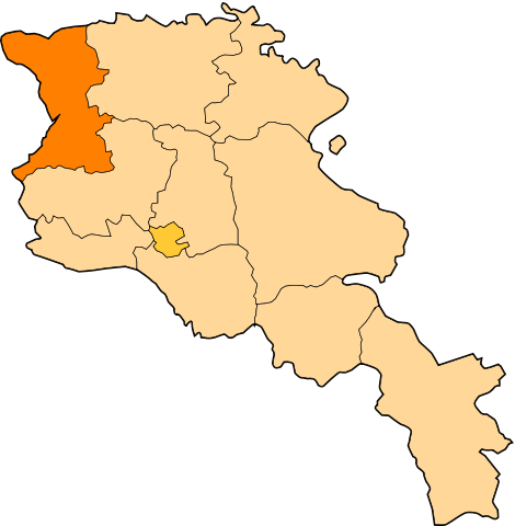
| Sıpatlama | Image shows the eleven administrative subdivisions of Armenia: # Aragatsotn (Արագածոտնի) # Ararat (Արարատի) # Armavir (Արմավիրի) # Gegharkunik (Գեղարքունիքի) # Kotayk (Կոտայքի) # Lori (Լոռու) # Shirak (Շիրակի) # Syunik (Սյունիքի) # Tavush (Տավուշի) # Vayots Dzor (Վայոց Ձորի) # Yerevan (Երևան) - special administrative status Derived from a multiple of public sources and created using Inkscape. == |
| Sáne | (UTC) |
| Fayl deregi | |
| Avtor |
|
| This is a retouched picture, which means that it has been digitally altered from its original version. Modifications: Creation d'une autre map. The original can be viewed here: Armenia map numbered.svg:
|
Bul fayl Creative Commons tiykarında licenziyalanǵan org/licenses/by-sa/3.0/deed.en Attribution-Share Alike 3.0 Unported licenziyası.
- Siz bossız:
- Bólisiw – Jumıstı nusqalaw, tarqatıw hám uzatıw
- Remiks qılıw – Jumısqa beyimlesiw
- Tómendegi shártler tiykarında :
- atribut – Siz tiyisli kredit beriwińiz, licenziyaǵa siltemeni usınıwıńız hám ózgertiwler kiritilgenligin kórsetiwińiz kerek. Siz bunı hár qanday aqılǵa say jol menen etiwińiz múmkin, biraq licenziar sizdi yamasa siziń paydalanıwıńızdı maqullawın usınıs etetuǵın tárizde emes.
- birdey shártlerde taratıw – Eger siz materialdı remiks qılsańız, ózgertseńiz yamasa oǵan tiykarlansańiz, óz úleslerińizdi túp nusqadaǵı sıyaqlı birdey yamasa uyqas licenziya tiykarında tarqatıwıńız kerek.
Тұпнұсқа жүктеу журналы
This image is a derivative work of the following images:
- File:Armenia_map_numbered.svg licensed with Cc-by-sa-3.0-migrated, GFDL
- 2010-09-26T17:27:10Z 6AND5 725x740 (82221 Bytes) Reverted to version as of 17:31, 25 November 2006 (((Exclaves deleted according to official map at http://www.gov.am/en/regions/)))
- 2006-11-25T19:37:43Z Bastique 725x740 (87638 Bytes) Cleanup
- 2006-11-25T19:26:57Z Bastique 725x740 (86083 Bytes) Enclaves
- 2006-11-25T17:31:38Z Bastique 725x740 (82221 Bytes) Fixed canvas size
- 2006-11-25T17:27:59Z Bastique 744x1052 (79767 Bytes) Image shows the subdivisions of Armenia. Derived from a multiple of public sources and created using Inkscape. == Licensing == {{GFDL}} Image shows the eleven administrative subdivisions of Armenia: #[[Aragatsotn]] (Ար�
Uploaded with derivativeFX
Fayl tariyxı
Aldın usı fayl qanday kóriniste bolǵanın kóriw ushin kún-ay/waqıt degendi basıń.
| Sáne/Waqıt | Miniatyurası | Ólshemleri | Paydalanıwshı | Pikir | |
|---|---|---|---|---|---|
| házirgi | 12:12, 2010 j. dekabrdiń 30 | | 725 × 740 (72 КБ) | Varmin | {{Information |Description=Image shows the eleven administrative subdivisions of Armenia: # Aragatsotn (Արագածոտնի) # Ararat (Արարատի) # Armavir (Արմավիրի) # Gegharkunik (Գեղ |
Fayldıń paydalanılıwı
Tómendegi dana bette bul fayl paydalanılǵan:
Fayldı global paydalanıw
Tómendegi basqa wikilar bul fayldan paydalanadı:
- ar.wikipedia.org joybarında qollanıw
- be.wikipedia.org joybarında qollanıw
- bg.wikipedia.org joybarında qollanıw
- Гюмри
- Ширак
- Арпени
- Маралик
- Артик
- Геганист (област Ширак)
- Наапетаван
- Шаблон:Област Ширак
- Агворик
- Агин (село)
- Азатан
- Айгабац
- Айкаван (област Ширак)
- Айкадзор
- Айкасар
- Айреняц
- Алвар (област Ширак)
- Амасия (област Ширак)
- Аниаван
- Анипемза
- Анушаван
- Аравет
- Арапи
- Арденис
- Аревик (област Ширак)
- Аревшат (област Ширак)
- Арташен (област Ширак)
- Арегнадем
- Арич
- Ахурик
- Ахурян (село)
- Ацик (област Ширак)
- Ашоцк
- Бавра
- Баграван
- Бандиван
- Барцрашен (Ширак)
- Башгюх
- Баяндур
- Бениамин
- Бердашен (област Ширак)
- Вахрамаберд
- Вардакар
- Вардахпюр
Bul fayldıń kóbirek global paydalanıw bólimin kóriń.